9.Du J, He Z, Chen L, et al. Integrating lidar with Landsat data for subalpine temperate forest aboveground carbon estimation. International Journal of Remote Sensing, 2015, 36(23): 5767-5789. (IF=1.640)
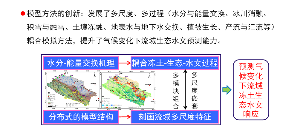
10.Gao B, Qin Y, Wang Y, et al. Modeling Ecohydrological Processes and Spatial Patterns in the Upper Heihe Basin in China. Forests, 2015, 7(1): 10. (IF=1.583)
11.Jin R, Zhang T, Li X, et al. Mapping surface soil freeze-thaw cycles in China based on SMMR and SSM/I brightness temperatures from 1978 to 2008. Arctic, Antarctic, and Alpine Research, 2015, 47(2): 213-229. (IF=1.455)
12.Li X, Zhang G L, He C. Watershed science: Bridging new advances in hydrological science with good management of river basins. Science China. Earth Sciences, 2015, 58(1): 1-2. (IF=1.655)
13.Ran Y, Li X, Jin R, et al. Remote sensing of the mean annual surface temperature and surface frost number for mapping permafrost in China. Arctic, Antarctic, and Alpine Research, 2015, 47(2): 255-265. (IF=1.455)
14.Wang X, Cheng G, Li X, et al. A comparison of two photosynthesis parameterization schemes for an alpine meadow site on the Qinghai-Tibetan Plateau. Theoretical and Applied Climatology, 2015: 1-14. (IF=2.433)
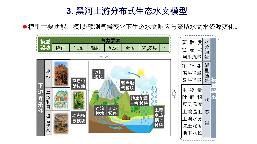
15.Yang D, Gao B, Jiao Y, et al. A distributed scheme developed for eco-hydrological modeling in the upper Heihe River. Science China Earth Sciences, 2015, 58(1): 36-45. (IF=1.655)
16.Zhang Y, Li X, Wen J, et al. Improved Topographic Normalization for Landsat TM Images by Introducing the MODIS Surface BRDF. Remote Sensing, 2015, 7(6): 6558-6575. (IF=3.036)
17.Cong Z, Shahid M, Zhang D, et al. Attribution of runoff change in the alpine basin: a case study from Heihe upstream basin, China. Hydrological Sciences Journal, 2016. (in press). (IF=2.182)
18.Fang M, Li X. Application of Bayesian Model Averaging in the Reconstruction of Past Climate Change Using PMIP3/CMIP5 Multimodel Ensemble Simulations. Journal of Climate, 2016, 29(1): 175-189.
19.Fang M, Li X. Paleoclimate data assimilation: Its motivation, progress and prospects. Science China Earth Sciences, 2016, 59(9): 1817-1826.
20.Huang Z, Yang H, Yang D. Dominant climatic factors driving annual runoff changes at the catchment scale across China. Hydrology and Earth System Sciences, 2016, 20(7): 2573-2587.
21.Cong Z, Zhang X, Li D, et al. Understanding hydrological trends by combining the Budyko hypothesis and a stochastic soil moisture model. Hydrological Sciences Journal, 2015, 60(1): 145-155.
22.He Z, Du J, Zhao W, et al. Assessing temperature sensitivity of subalpine shrub phenology in semi-arid mountain regions of China. Agricultural and Forest Meteorology, 2015, 213: 42-52.
23.Li H Y, He Y Q, Hao X H, et al. Downscaling Snow Cover Fraction Data in Mountainous Regions Based on Simulated Inhomogeneous Snow Ablation. Remote Sensing, 2015, 7(7): 8995-9019.
24.Lu Z, Zou S, Xiao H, et al. Comprehensive hydrologic calibration of SWAT and water balance analysis in mountainous watersheds in northwest China. Physics and Chemistry of the Earth, Parts A/B/C, 2015, 79: 76-85.
25.Pan X, Li X, Cheng G, et al. Development and Evaluation of a River-Basin-Scale High Spatio-Temporal Precipitation Data Set Using the WRF Model: A Case Study of the Heihe River Basin. Remote Sensing, 2015, 7(7): 9230-9252.
26.Tian H, Lan Y, Wen J, et al. Evidence for a recent warming and wetting in the source area of the Yellow River (SAYR) and its hydrological impacts. Journal of Geographical Sciences, 2015, 25(6): 643-668.
27.Zhang Y, Li X, Bai Y. An integrated approach to estimate shortwave solar radiation on clear-sky days in rugged terrain using MODIS atmospheric products. Solar Energy, 2015, 113: 347-357.
28.Yang H, Qi J, Xu X, et al. The regional variation in climate elasticity and climate contribution to runoff across China. Journal of Hydrology, 2014, 517: 607-616.
29.Yang H, Yang D, Hu Q. An error analysis of the Budyko hypothesis for assessing the contribution of climate change to runoff. Water Resources Research, 2014, 50(12): 9620-9629.
30.Zhang X, Cong Z. Trends of precipitation intensity and frequency in hydrological regions of China from 1956 to 2005. Global and Planetary Change, 2014, 117: 40-51.
31.Pan B, Cong Z. Information Analysis of Catchment Hydrologic Patterns across Temporal Scales. Advances in Meteorology, 2016.
32.Zou S, Ruan H, Lu Z, et al. Runoff Simulation in the Upper Reaches of Heihe River Basin Based on the RIEMS–SWAT Model. Water, 2016, 8(10): 455.
33.Zhu X, He Z, Chen L, et al. Changes in Species Diversity, Aboveground Biomass, and Distribution Characteristics along an Afforestation Successional Gradient in Semiarid Picea crassifolia Plantations of Northwestern China. Forest Science, 2016.
34.Chen R, Liu J, Kang E, et al. Precipitation measurement intercomparison in the Qilian Mountains, north-eastern Tibetan Plateau. The Cryosphere, 2015, 9(5): 1995-2008.
35.Lu Z, Wei Y, Xiao H, et al. Evolution of the human–water relationships in the Heihe River basin in the past 2000 years. Hydrology and Earth System Sciences, 2015, 19(5): 2261-2273.
36.Lu Z, Wei Y, Xiao H, et al. Trade-offs between midstream agricultural production and downstream ecological sustainability in the Heihe River basin in the past half century. Agricultural Water Management, 2015, 152: 233-242.
37.Mo K, Cong Z, Lei H. Optimal vegetation cover in the Horqin Sands, China. Ecohydrology, 2015.9(4), 700-711.
38.Yang H, Li Z, Li M, et al. Inconsistency in Chinese solar radiation data caused by instrument replacement: Quantification based on pan evaporation observations. Journal of Geophysical Research: Atmospheres, 2015, 120(8): 3191-3198.
39.任璐、王顺利、于澎涛、王彦辉、张学陪、王彬、刘贤德、金铭,2016,.祁连山2种植被下冻土的季节变化及数值模拟. 林业科学研究, 29(4):596-602.
40.王彬, 于澎涛, 王顺利等.祁连山北坡青海云杉林下苔藓层对土壤水分空间差异的影响.生态学报. 生态学报,2017,08:1-10.
41.万艳芳,于澎涛,刘贤德等. 祁连山青海云杉树干液流密度的优势度差异. 生态学报,2016,39(4).
42.王彬、于澎涛、王顺利等.祁连山区林地的土壤贮水量坡位响应. 中国水土保持科学,2016,14(3):164-173.
43.杨大文, 丛振涛, 尚松浩, 倪广恒. 从土壤水动力学到生态水文学的发展与展望. 水利学报, 2016, 47(3): 390-397.
44.Yang J, He Z, Zhao W. Assessing artificial neural networks coupled with wavelet analysis for multi-layer soil mois-ture dynamics prediction. Sciences in Cold and Arid Regions, 2016, 8(2): 0116-0124.
45.章诞武,丛振涛,倪广恒. 1956—2010年中国降雪特征变化. 清华大学学报(自然科学版),2016,04:381-386+393.
46.丁宏伟, 郭瑞, 蓝永超, 等. 再论巴丹吉林沙漠湖泊水的补给来源, 补给模式与高大沙山的形成机理. 冰川冻土, 2015, 37(3): 783-792.
47.蓝永超,胡兴林,丁宏伟等.黑河山区气温、降水的季节变化特征及其区域差异分析. 山地学报,2015,33(3),179-189.
48.陆志翔, 邹松兵, 肖洪浪, 等. 黑河上游高寒山区集水面积阈值确定方法探讨. 冰川冻土, 2015, 37(2): 493-499.
49.王宇涵, 杨大文, 雷慧闽, 杨汉波. 冰冻圈水文过程对黑河上游径流的影响分析. 水利学报, 2015, 09: 1064-1071.
50.章诞武,丛振涛,倪广恒. 1956—2010年中国水热季节性特征分析. 水科学进展,2015,04:466-472.
51.张雷、于澎涛、王彦辉等. 祁连山北坡青海云杉中龄林结构随海拔的变化. 林业科学研究,2015,04:557-564.
52.张雷、于澎涛、王彦辉等. 祁连山北坡青海云杉中龄林生物量随海拔的变化. 林业科学,2015,51(8):1-7.
53.周继华, 来利明, 郑元润.一种模型模拟结果的统计检验方法. 生态学报,2015,35(19): 6435-6438.
54.蓝永超,胡兴林,丁宏伟等.河西内陆河流域山区近50余年来气温变化的多尺度特征和突变分析,山地学报,2014,32(2),163-171. (《山地学报》2014年度高影响力论文).
55.Lan Y, Jin H, La C, et al. Climate transformation to warm-humid and its effect on river runoff in the source region of the Yellow River. Sciences in Cold and Arid Regions. 2014, 6(3),257-265.
56.蓝永超, 沈永平, 丁宏伟等. 1960s以来河西内陆河流域山区降水变化及其区域性差异分析.冰川冻土,2013,35(6):1474-1480.
57.蓝永超, 胡兴林,丁宏伟等.气候变暖背景下祁连山区西部水循环要素的变化. 山地学报,2012.30(6):675-680.
58.蓝永超,沈永平,高前兆等. 近50年疏勒河流域山区的气候变化及其对出山径流的影响.高原气象, 2012,33(6):1275-1281.
59.蓝永超,胡兴林,丁宏伟等.黑河山区径流的季节变化特征及其区域差异分析. 山地学报,(待刊).
60.张晓龙, 周继华, 蔡文涛等. 水分梯度下黑河流域荒漠植物群落多样性特征. 生态学报 (待刊).
61.蓝永超, 刘根生, 朱云通等.黄河源区气候变化的季节特征与区域差异研究.冰川冻土, 2016, 38(3): 1259-1267.
62.王磊, 陈仁升, 宋耀选. 基于Γ函数的祁连山葫芦沟流域湿季小时降水统计特征. 地球科学进展, 2016, 31(8): 840-848.
63.万艳芳,刘贤德,于澎涛等. 李晓青祁连山鲜黄小檗灌丛穿透雨特征及其影响因素. 南京林业大学学报,2016, 1-8.
64.李晓青,于澎涛,刘贤德等. 祁连山青海云杉直径结构及其对径向生长的影响. 干旱区研究(待刊).
65.王希强,陈仁升,刘俊峰. 气候变化背景下祁连山区负积温时空变化特征分析. 高原气象(待刊).